

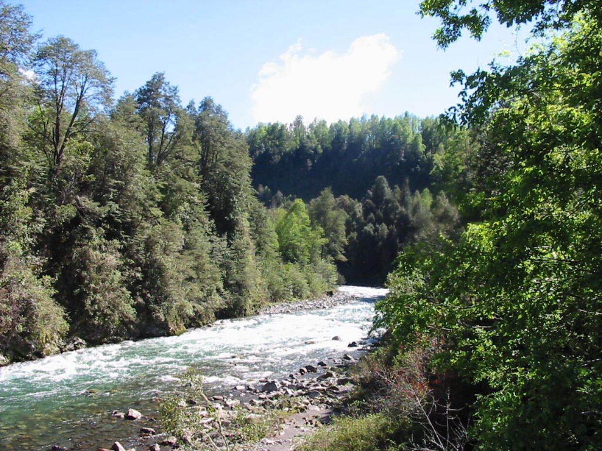
As its name suggests, the geography and also the identity of the Los Ríos Region are determined by the many rivers that flow through it. With an annual rainfall of over 2000 mm, it is one of the wettest areas of the country; although the rain falls throughout the year, most precipitation occurs during the winter months. The Andes are relatively low in altitude, about 2,000 metres at this latitude, but include some imposing peaks such as Choshuenco and Puyehue volcanoes. The mountains are covered with dense vegetation, which is known as Valdivian rainforest, named after the regional capital, Valdivia. Between the Andes and the Intermediate Depression are a network of expansive lakes including, Pirihueico, Calafquén, Riñihue and Neltume, each connected and drained by the Valdivia river. Another important river, the Cruces, has an associated extensive wetland that was formed as a result of the 1960 earthquake and tsunami (9.5 on the Richter scale). The central valley has gentle hills that have been highly modified by intensive agriculture and ever-expanding forestry. The coastal mountain range is notably low and sometimes it peters out into the coastal plains. Los Ríos Region has over 160 endemic plants species with seven being unique to the Region and of these, Valdiva gayana (which is also an endemic genus) is the most notable.
Endemic Taxa in Los Ríos
- Acmispon subpinnatus (Lag.) D.D.Sokoloff
- Acrisione cymosa (J.Rémy) B.Nord.
- Adesmia elata Clos
- Agrostis arvensis Phil.
- Agrostis trisetoides Steud.
- Alopecurus lechleri Steud.
- Amomyrtus meli (Phil.) D. Legrand & Kausel
- Anemone hepaticifolia Hook.
- Anthoxanthum utriculatum var. altissimum (Steud.) N. Villalobos
- Antidaphne punctulata (Clos) Kuijt
- Asplenium obtusatum G. Forst. var. sphenoides (Kunze) C. Chr. ex Skottsb.
- Asplenium patagonicum R.A. Rodr. & R. Guzmán
- Asteriscium chilense Cham. & Schltdl.
- Austroblechnum asperum (Klotzsch) Gasper & V.A.O.Dittrich
- Austroblechnum corralense (Espinosa) Gasper & V.A.O.Dittrich
- Austroblechnum leyboldtianum (Phil.) Gasper & V.A.O.Dittrich
- Azara integrifolia Ruiz & Pav.
- Azara serrata Ruiz & Pav. var. serrata
- Baccharis cymosa Phil.
- Baccharis rhomboidalis J. Rémy
- Baccharis sphaerocephala Hook. & Arn.
- Berberidopsis corallina Hook.f.
- Berberis congestiflora Gay
- Berberis valdiviana Phil.
- Blepharocalyx cruckshanksii (Hook. & Arn.) Nied.
- Calandrinia pilosiuscula DC
- Calceolaria integrifolia L.
- Calceolaria valdiviana Phil. ssp. crassifolia (Phil.) C. Ehrh.
- Carex chlorolepis Steud.
- Carex dolichophylla J.R.Starr
- Carex multifaria (Nees ex Boott) J.R.Starr
- Carex quinquin Jim.-Mejías & Dorr
- Carex trichodes Steud. ex Boott
- Carex werdermannii Gross
- Chascolytrum koelerioides (Trin.) Essi, Longhi-Wagner & Souza-Chies
- Chloraea cuneata Lindl.
- Chloraea gavilu Lindl.
- Chloraea lamellata Lindl.
- Chusquea macrostachya Phil.
- Chusquea montana Phil. f. nigricans (Phil.) Matthei
- Chusquea quila Kunth
- Chusquea uliginosa Phil.
- Cissarobryon elegans Kunze ex Poepp.
- Citronella mucronata (Ruiz & Pav.) D. Don
- Corynabutilon ochsenii (Phil.) Kearney
- Corynabutilon vitifolium (Cav.) Kearney
- Crinodendron hookerianum Gay
- Danthonia araucana Phil
- Danthonia chilensis E. Desv. var. aureofulva (E. Desv.) Baeza
- Danthonia malacantha (Steud.) Pilg.
- Desmaria mutabilis (Poepp. & Endl.) Tiegh. ex T.Durand & B.D.Jacks.
- Dioscorea cissophylla Phil.
- Dioscorea nana Poepp.
- Drimys winteri var. chilensis (DC.) A.Gray
- Elaphoglossum fonkii (Phil.) T.Moore
- Eleocharis cordillerana S. González, Guagl. & Ruthsatz
- Ercilla spicata (Bertero) Moq.
- Ercilla syncarpellata Nowicke
- Escallonia revoluta (Ruiz & Pav.) Pers.
- Escallonia rubra (Ruiz & Pav.) Pers. var. macrantha (Hook. & Arn.) Reiche
- Euphrasia trifida Poepp ex Benth.
- Fascicularia bicolor (Ruiz & Pav.) Mez ssp. bicolor
- Fascicularia bicolor (Ruiz & Pav.) Mez ssp. canaliculata E.C.Nelson & Zizka
- Francoa appendiculata Cav.
- Galium araucanum Phil.
- Gamochaeta carloramirezii Chaura & C.M. Baeza
- Gardoquia multiflora Ruiz & Pav.
- Gavilea cardioglossa (Reiche) Martic.
- Gavilea venosa (Lam.) Garay & Ormd.
- Geum quellyon Sweet
- Gochnatia foliolosa (D. Don) D. Don ex Hook. & Arn. var. foliolosa
- Grausa gayana (Urb. & Gilg) Weigend & R.H.Acuña,
- Grausa martini (Phil.) Weigend & R.H.Acuña
- Greigia landbeckii (Lechl. ex Phil.) Phil. ex F.Phil.
- Greigia pearcei Mez
- Greigia sphacelata (Ruiz & Pav.) Regel
- Griselinia jodinifolia (Griseb.) Taub.
- Hydrocotyle poeppigii DC.
- Hymenophyllum cuneatum Kunze var. cuneatum
- Hymenophyllum dicranotrichum (C. Presl) Hook. ex Sadeb.
- Hypochaeris spathulata (J. Rémy) Reiche
- Jovellana punctata Ruiz & Pav.
- Jovellana violacea (Cav.) G. Don
- Lapageria rosea Ruiz & Pav.
- Lardizabala biternata Ruiz & Pav.
- Latua pubiflora (Griseb.) Baill.
- Laurelia sempervirens (Ruiz & Pav.) Tul.
- Lepechinia chilensis (Molina) R.Morales
- Leptocarpha rivularis DC.
- Libertia sessiliflora (Poepp.) Skottsb.
- Libertia tricocca Phil.
- Loasa triloba Dombey ex Juss.
- Lobelia bridgesii Hook. & Arn.
- Lobelia tupa L.
- Luma chequen (Molina) A.Gray
- Luzuriaga polyphylla (Hook.) J.F. Macbr.
- Madia chilensis (Nutt.) Reiche
- Melica violacea Cav.
- Menonvillea filifolia Fisch. & C.A. Mey.
- Myrceugenia ovata (Hook. & Arn.) O. Berg var. ovata
- Myrceugenia parvifolia (DC.) Kausel
- Nassella chilensis (Trin.) E. Desv. var. juncea (Phil.) M. Muñoz
- Nassella macrathera (Phil.) Barkworth
- Nolana paradoxa Lindl.
- Notanthera heterophylla (Ruiz & Pav.) G. Don
- Noticastrum antucense Phil.
- Noticastrum erectum J.Rémy
- Oenothera acaulis Cav.
- Oenothera ravenii W. Dietr. ssp. chilensis W. Dietr.
- Olsynium junceum subsp. depauperatum (Phil.) R.Rodr. & Martic.
- Ourisia coccinea (Cav.) Pers. ssp. elegans (Phil.) Meudt
- Ourisia polyantha Poepp. & Endl.
- Ovidia pillo-pillo (Gay) Meisn.
- Oxalis arenaria Bertero ex Colla
- Oxalis aureoflava Steud.
- Oxalis dumetorum Barnéoud
- Oxalis rosea Jacq.
- Paspalum chilense Catanzaro & G.H. Rua,
- Peperomia fernandeziana Miq.
- Peperomia nummularioides Griseb.
- Peumus boldus Molina
- Phycella chilensis (L’Hér.) Grau ex Nic.García
- Phycella fulgens (Hook.f.) Nic.García
- Pilea elegans Gay
- Pilea elliptica Hook. f.
- Piptochaetium depressum (Steud.) C. Peña
- Plantago firma Kunze ex Walp.
- Plantago hispidula Ruiz & Pav.
- Plantago truncata Cham. & Schltdl.
- Poa cumingii Trin.
- Poa schoenoides Phil.
- Podocarpus salignus D.Don
- Polypogon elongatus Kunth var. strictus E. Desv.
- Proustia pyrifolia DC.
- Pteris chilensis Desv.
- Rhamnus diffusus Clos
- Rumex maricola J.Rémy
- Sagittaria montevidensis Cham. & Schltdl. ssp. chilensis (Cham. & Schltdl.) Bogin
- Samolus latifolius Duby
- Sarmienta scandens (J.D.Brandis ex Molina) Pers.
- Schizanthus pinnatus Ruiz & Pav.
- Scirpus melanocaulos Phil.
- Scutellaria valdiviana (Clos) Epling
- Selkirkia limense (Willd.) Holstein & Weigend
- Selkirkia pauciflora (Ruiz & Pav.) Holstein & Weigend
- Senecio arnicoides Hook. & Arn.
- Senecio buglossus Phil.
- Senecio calocephalus Poepp.
- Senna stipulacea (Aiton) H.S. Irwin & Barneby var. stipulacea
- Sisyrinchium pearcei Phil.
- Solenomelus pedunculatus (Gillies ex Hook.) Hochr.
- Sophora cassioides (Phil.) Sparre
- Stachys bridgesii Benth.
- Stachys macraei Benth.
- Sticherus litoralis (F.Phil.) Nakai
- Sticherus squamulosus (Desv.) Nakai var. gunckelianus (Looser) R. Rodr. & Ponce
- Sticherus squamulosus (Desv.) Nakai var. squamulosus
- Teucrium bicolor Sm.
- Trichomanes exsectum Kunze
- Triptilion spinosum Ruiz & Pav.
- Tropaeolum speciosum Poepp. & Endl.
- Ugni candollei (Barnéoud) O.Berg
- Valdivia gayana J.Rémy
- Valeriana obtusifolia DC.
- Valeriana valdiviana Phil.
- Viola portalesia Gay var. portalesia
- Viola rubella Cav.
- Viola rudolphii Sparre